
Displacement identification methods are shaping the future of disaster recovery, offering powerful ways to track structural movement and population shifts. Now get this. A single camera powered by deep learning can measure three-dimensional displacement with surprising accuracy, cutting equipment costs dramatically. But here’s a twist that most overlook. The true breakthroughs are not just high-tech—success comes down to combining these tools with community insight and human decision making, unlocking impacts far beyond what sensors and software can do alone.
Table of Contents
- Understanding Displacement Identification Methods
- Key Applications In Disaster Recovery
- Technology And Tools Supporting Identification
- Best Practices For Stakeholders
Quick Summary
| Takeaway | Explanation |
|---|---|
| Embrace Advanced Optical Techniques | Utilize Digital Image Correlation (DIC) and monocular vision-based methods for precise, cost-effective structural displacement tracking. |
| Integrate Technology for Enhanced Monitoring | Combine sensor technologies and machine learning tools to create comprehensive displacement monitoring systems that provide real-time insights and predictive capabilities. |
| Foster Community Engagement | Involve community members in decision-making and planning processes to respect diverse perspectives and enhance the effectiveness of displacement management strategies. |
| Develop Coordination Protocols | Establish standardized procedures among agencies and organizations to streamline data collection, sharing, and response efforts in disaster situations. |
| Prioritize Continuous Training | Invest in ongoing professional development for stakeholders to stay updated with the latest technologies and ethical practices in displacement identification. |
Understanding Displacement Identification Methods
Displacement identification methods represent critical technological approaches for measuring and analyzing structural movements across various contexts. These techniques provide essential insights into how objects or structures change position under different conditions, which is crucial for engineering, disaster response, and structural safety assessments.
Optical and Vision-Based Tracking Techniques
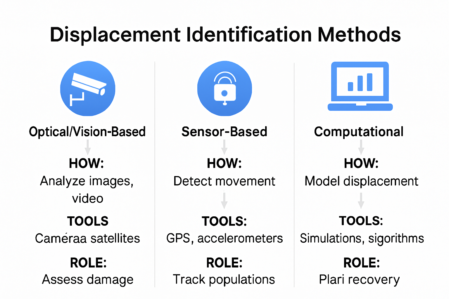
Modern displacement identification relies heavily on advanced optical methodologies. Digital Image Correlation (DIC) emerges as a sophisticated non-contact optical method capable of measuring full-field displacements with exceptional precision. This technique analyzes surface images before and after deformation, creating detailed maps of structural movements.
Recent advancements in computer vision have revolutionized displacement tracking. According to recent research, monocular vision-based methods now enable three-dimensional structural displacement measurement using deep learning-based pose estimation. These innovative approaches allow researchers and engineers to track structural movements using a single camera, significantly reducing equipment costs and complexity.
Sensor-Based Displacement Detection
Traditional displacement identification methods rely on various sensor technologies to capture precise movement data. Strain gauges, accelerometers, and laser displacement sensors provide quantitative measurements of structural deformations. Each sensor type offers unique advantages depending on the specific application and environment.
Instrument selection depends on multiple factors including measurement range, required accuracy, environmental conditions, and accessibility of the monitored structure. Some sensors excel in detecting microscopic movements, while others are designed for large-scale structural monitoring. The choice of displacement identification method directly impacts the reliability and usefulness of collected data.
Computational Analysis and Data Interpretation
Advanced computational techniques transform raw displacement data into meaningful insights. Machine learning algorithms and sophisticated signal processing methods help researchers extract complex patterns and predict potential structural behaviors. These computational approaches enable more nuanced understanding of displacement mechanisms across engineering, architectural, and disaster response domains.
The integration of multiple displacement identification methods provides comprehensive monitoring capabilities. By combining optical tracking, sensor-based detection, and advanced computational analysis, professionals can develop robust strategies for assessing structural integrity, predicting potential failures, and implementing proactive maintenance protocols.
Displacement identification is not just a technical exercise but a critical tool for ensuring safety, understanding structural performance, and mitigating potential risks in various environments. As technology continues to evolve, these methods will become increasingly sophisticated, offering unprecedented insights into how structures respond to different forces and conditions.
To clarify the differences and benefits of both optical and sensor-based displacement identification techniques, see the summary table below.
| Method | Key Technology | Advantages | Common Applications |
|---|---|---|---|
| Digital Image Correlation | Optical image analysis | Non-contact, full-field, highly precise | Structural monitoring, civil engineering |
| Monocular Vision-Based | Single camera, deep learning | 3D measurement, reduced cost and complexity | Structural displacement, rapid deployments |
| Strain Gauges | Electrical resistance sensors | High accuracy, microscopic measurement | Laboratories, bridges, critical structures |
| Accelerometers | Motion sensors | Dynamic displacement measurement, real-time data | Seismic monitoring, buildings |
| Laser Displacement Sensors | Laser-based | Precise, long-range, remote measurement | Large-scale infrastructures |
Key Applications in Disaster Recovery
Displacement identification methods play a critical role in disaster recovery efforts, providing essential insights that help communities and emergency responders navigate complex post-disaster scenarios. These techniques go beyond simple measurement, offering strategic understanding of population movements and structural impacts.
Population Displacement Assessment
Understanding population displacement is crucial for effective disaster response. Research in the Natural Hazards journal introduced a Displacement Risk Index (DRI) that integrates social, environmental, and economic indicators to assess community vulnerability. This innovative approach helps emergency management teams predict and prepare for potential population movements following catastrophic events.
The National Disaster Recovery Framework emphasizes the importance of coordinated efforts among federal, state, and local agencies to restore and revitalize communities. Displacement identification methods provide critical data that supports these comprehensive recovery strategies, enabling more targeted and efficient resource allocation.
Structural Damage and Recovery Planning
Displacement identification techniques offer precise measurements of structural changes, which are fundamental to recovery planning. By mapping subtle and significant structural movements, emergency professionals can:
- Evaluate Building Integrity: Quickly assess the safety and potential rehabilitation requirements of damaged structures.
- Prioritize Reconstruction Efforts: Identify which buildings and infrastructure require immediate attention.
- Predict Long-Term Structural Risks: Understand potential future degradation based on current displacement patterns.
A comprehensive study in the Natural Hazards Review highlights advanced models that estimate population displacement by incorporating factors like structural damage, utility disruptions, and socioeconomic demographics. These models provide nuanced insights that go beyond traditional assessment methods.
Risk Mitigation and Future Preparedness
Displacement identification is not just about immediate response but also about long-term resilience. By analyzing displacement patterns, communities can develop more robust emergency preparedness strategies. This proactive approach allows for:
- Improved infrastructure design
- More effective evacuation planning
- Enhanced early warning systems
- Strategic urban development considerations
For those interested in understanding the broader context of disaster recovery technologies, our comprehensive guide on technological innovations provides deeper insights into emerging methodologies.
As climate change and environmental challenges increase the frequency and intensity of disasters, displacement identification methods will become increasingly vital. These techniques represent more than just technical measurements they are powerful tools for community resilience, offering hope and practical solutions in the face of unprecedented challenges.

Technology and Tools Supporting Identification
Technology has revolutionized displacement identification methods, providing increasingly sophisticated tools that enable precise measurement and analysis across various domains. Modern technological solutions offer unprecedented capabilities for tracking and understanding structural and population movements with remarkable accuracy.
Advanced Imaging and Sensing Technologies
Cutting-edge imaging technologies have transformed displacement identification approaches. Unmanned aerial vehicles (UAVs) combined with advanced computer vision techniques now enable three-component displacement measurements in structures. These portable systems provide efficient monitoring capabilities, especially in challenging or hard-to-access environments.
Digital image correlation techniques have seen significant advancements. Researchers recently introduced Deep DIC, a deep learning-based method that offers end-to-end displacement and strain measurement. This innovative approach enhances accuracy, particularly when dealing with large and localized deformations, representing a significant leap forward in measurement technologies.
Computational and Machine Learning Tools
Machine learning algorithms have become integral to displacement identification processes. These sophisticated computational tools can:
- Process Complex Data: Analyze massive datasets with unprecedented speed and accuracy
- Predict Structural Behaviors: Identify potential movement patterns before they become critical
- Reduce Human Error: Provide objective, data-driven insights
Advanced software platforms now integrate multiple sensor inputs, creating comprehensive monitoring systems that can track displacements across various scales and environments. These tools transform raw data into actionable insights, enabling more proactive decision-making in disaster response and structural management.
Sensor Integration and Real-Time Monitoring
Modern displacement identification relies on integrated sensor networks that provide real-time, comprehensive monitoring. These systems combine multiple technologies including:
- Laser displacement sensors
- Accelerometers
- Fiber optic strain gauges
- High-resolution camera systems
- Wireless sensor networks
For professionals seeking deeper understanding of technological innovations in disaster response, our comprehensive technology guide offers additional insights into emerging methodologies.
The convergence of advanced sensors, computational power, and machine learning is transforming displacement identification from a reactive to a predictive discipline. These technologies not only measure current conditions but also anticipate potential future movements, providing unprecedented capabilities for risk management and emergency preparedness.
As technological capabilities continue to expand, displacement identification methods will become increasingly precise, adaptable, and critical in understanding complex structural and environmental dynamics. The future of this field lies in continuous innovation, integration of multiple data sources, and the development of more intelligent, adaptive monitoring systems.
To help you quickly understand the contribution of the latest technological tools discussed, here is a summary table:
| Technology/Tool | Main Function | Benefit |
|---|---|---|
| UAVs + Computer Vision | 3D displacement measurement | Portable, efficient, hard-to-access areas |
| Deep DIC | Deep learning-based DIC analysis | Increased accuracy on large/local deformations |
| Integrated Sensor Networks | Real-time monitoring | Comprehensive, multi-point, rapid alerts |
| Machine Learning Algorithms | Pattern/prediction from data | Predictive insights, reduce human error |
| Multi-Sensor Software | Data fusion & analysis | Actionable, consolidated decision support |
Best Practices for Stakeholders
Effective displacement identification requires collaborative and strategic approaches from multiple stakeholders. Each group plays a crucial role in ensuring accurate assessment, timely response, and comprehensive support for affected populations.
Community and Resident Engagement
The Urban Institute emphasizes the critical importance of integrating residents’ lived experiences with quantitative data analysis. This approach transforms displacement identification from a purely technical exercise into a human-centered process that respects community perspectives.
Successful engagement involves:
- Transparent Communication: Sharing displacement assessment methodologies and findings
- Inclusive Decision Making: Involving community members in planning and recovery strategies
- Cultural Sensitivity: Recognizing diverse community needs and perspectives
The National Academies of Sciences recommends collaborative planning that actively involves affected communities in developing relocation and recovery strategies. This approach ensures more effective, empathetic, and sustainable displacement management.
Institutional Coordination and Protocols
Multi-agency collaboration is fundamental to effective displacement identification. Government agencies, emergency services, insurance providers, and relief organizations must develop standardized protocols for:
- Rapid data collection and sharing
- Coordinated assessment methodologies
- Streamlined communication channels
- Integrated support systems
Implementing comprehensive information management systems allows real-time data exchange, enabling faster and more targeted responses. These systems should prioritize data privacy, security, and ethical use of sensitive information.
Technical Training and Capacity Building
Stakeholders must invest in continuous professional development to stay current with emerging displacement identification technologies and methodologies. Key training areas include:
- Advanced geospatial analysis techniques
- Machine learning and data interpretation skills
- Ethical data collection and privacy protocols
- Interdisciplinary collaboration strategies
For professionals seeking to enhance their understanding of technological innovations in disaster response, our comprehensive technology guide provides valuable insights into emerging methodologies.
Effective displacement identification is more than a technical challenge it is a complex social and human endeavor. By prioritizing collaboration, technological innovation, and community-centered approaches, stakeholders can develop more resilient, responsive, and compassionate displacement management strategies.
As global challenges like climate change and urbanization increase displacement risks, the ability to adapt, learn, and work together becomes increasingly critical. Stakeholders must remain committed to continuous improvement, interdisciplinary learning, and human-centered solutions.
Frequently Asked Questions
What are displacement identification methods?
Displacement identification methods are technological approaches used to measure and analyze structural movements and population shifts. These techniques are essential for engineering, disaster recovery, and safety assessments.
How do optical and sensor-based displacement identification techniques differ?
Optical techniques, like Digital Image Correlation, use images to measure movements without physical contact, while sensor-based techniques, such as accelerometers and strain gauges, rely on physical sensors to provide quantitative data on structural deformations.
What role do displacement identification methods play in disaster recovery?
These methods provide critical insights into population movements and structural impacts following disasters, allowing emergency responders to assess damage, allocate resources, and develop recovery strategies effectively.
How can community engagement enhance displacement identification efforts?
Involving community members in the decision-making process ensures that diverse perspectives are considered, fosters transparency, and enhances the effectiveness of displacement management strategies by making them more empathetic and responsive.
Turn Displacement Insights Into Real-World Recovery
This guide highlights how rapidly tracking displacement—whether of families or structures—can make the difference between chaos and control after a disaster. One clear pain point is the urgent need for reliable, accurate information to guide emergency housing, resource allocation, and support services. Many organizations struggle to translate advanced measurement techniques like deep learning or digital image correlation into fast, compassionate action for those who need it most.
DisasterVictimServices.com bridges this gap. We offer immediate expert assistance for individuals and families displaced by disaster, using the technology-driven insights discussed in this article to coordinate temporary housing, connect with insurance carriers, and work closely with first responders. When lives are disrupted in an instant, our team is ready to deliver both the logistical expertise and empathy you deserve.
Ready to put these proven identification methods into action for faster, safer recovery? Visit DisasterVictimServices.com now to discover how our hands-on solutions and collaborative approach lead the way from displacement to restoration. Or learn more about how our emergency response services can help you move forward with confidence today.
Recommended
- how to manage displacement – Disaster Victim Services | Helping You Recover After Disaster
- Housing Placement Workflow Guide 2025: Steps for Disaster Recovery – Disaster Victim Services | Helping You Recover After Disaster
- How to Manage Displacement: Practical Steps for Disaster Recovery 2025 – Disaster Victim Services | Helping You Recover After Disaster
- How to Handle Relocations in 2025: A Guide for Disaster Relief Teams – Disaster Victim Services | Helping You Recover After Disaster
- International Moving Process: UK Guide for 2025 Moves | Schott Removals